
Quick Answer
Cappadocia has seven essential hiking trails worth your time. Rose Valley and Red Valley are the most popular, each about 4 kilometers and 2 hours. Love Valley is shorter and easier, perfect for families. If you want something more challenging, Ihlara Valley offers 14 kilometers of canyon hiking with over 100 rock-cut churches. The hidden gems—Meskendir and Sword Valley—have far fewer tourists. We recommend April through June and September through October for hiking. Trails vary in marking quality, so know what to expect. Here’s what 25 years of guiding has taught me about these valleys.
Rose Valley (Güllüdere) — The Pink-Hued Classic
Rose Valley earned its name honestly. In the late afternoon, the rocks genuinely shift to pale pink and coral tones. The 3.5-kilometer loop typically takes 1.5 to 2 hours depending on how often you stop to photograph or explore side passages.
We usually start from Çavuşin village and descend into the valley floor. The path winds past rock-cut churches carved into the canyon walls. Some have faint Byzantine frescoes still visible if you know where to look. The main church structure here—what we call the Old Çavuşin church—sits partway up the north face. It’s not the finest example of church architecture in Cappadocia, but it’s meaningful because it shows how daily worship happened in these valleys.
The rocks genuinely justify the “rose” name, especially between 4 and 6 PM when the setting sun hits the west-facing cliffs. Bring a camera with good light sensitivity if you’re hiking this at that hour. The hike itself is easy to moderate. Most sections are manageable, though you’ll encounter some loose rock and short scrambles near churches.
Rose Valley connects to Red Valley via the northern ridge, so you can easily combine them for a 7-kilometer combined walk if you have 3.5 hours. Bring 1.5 to 2 liters of water—there are no water sources once you descend into the valley.
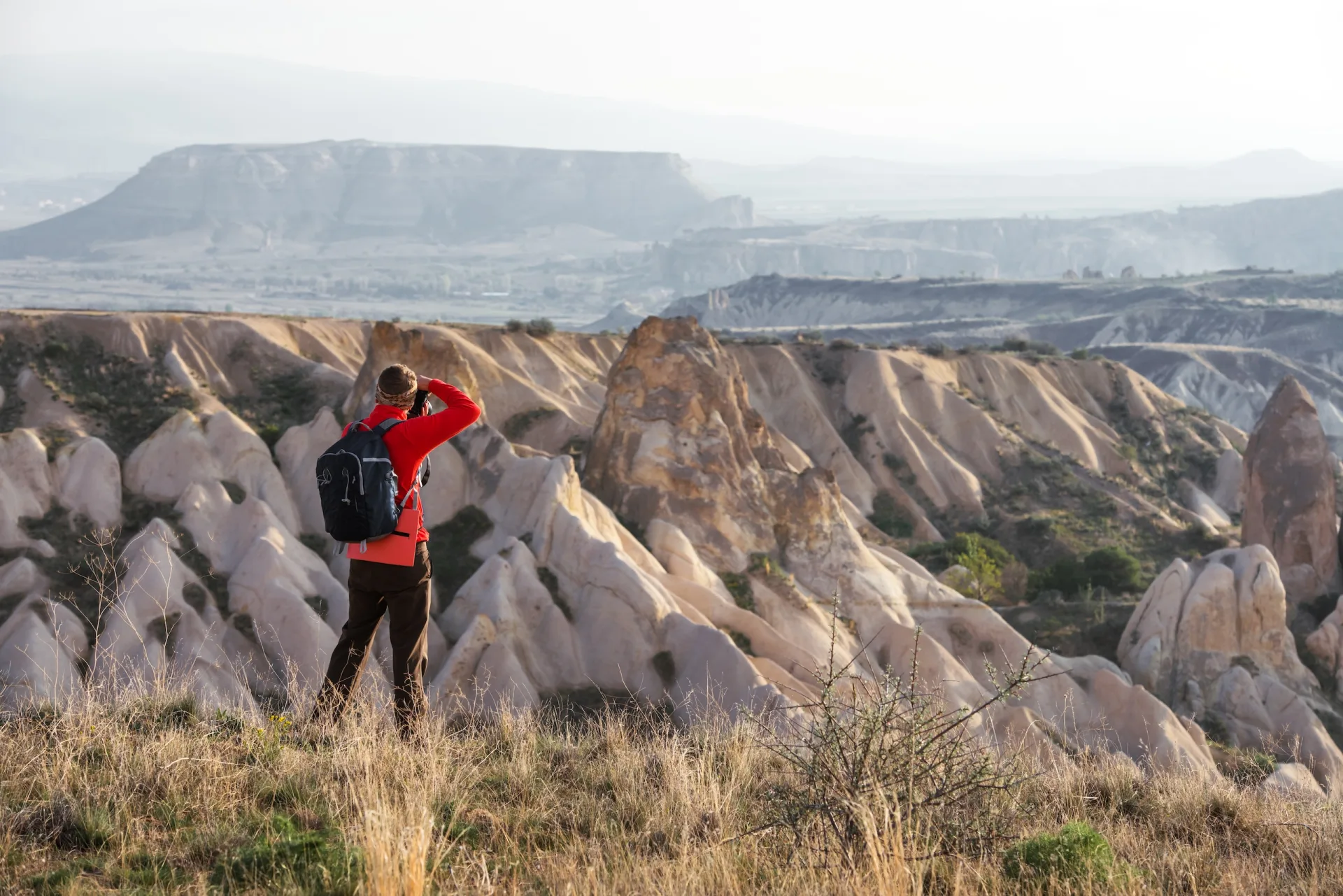
Red Valley (Kızılçukur) — Best Sunset Viewpoint
Don’t skip Red Valley just because it’s beside Rose Valley. They’re genuinely different experiences.
Red Valley stretches 4 kilometers through wine-red and rust-colored rock formations. The hike typically takes 1.5 to 2 hours at a comfortable pace. What makes this valley special is the viewpoint quality at the southern end. I’ve brought thousands of people to this spot, and I can count on one hand the number who weren’t moved by the sunset from there.
We typically start from Göreme village and walk the southern approach up toward Cavuşin. The red rock really does look red—not pink, but deep russet and burgundy. The coloration comes from iron oxide in the rock. In different light, it shifts. Morning light emphasizes the darker burgundy. Evening light turns it almost luminous.
The trail is moderate difficulty. You’ll need to navigate some steeper sections and rocky ground, but nothing requires climbing experience. The main challenge is that the trail can be dusty and loose underfoot—wear shoes with good ankle support.
What we tell people: if you can only do one sunset hike, do this one. Get there by 4 PM so you can explore the valley and find your preferred viewpoint before the light changes. The valleys fill with tour groups, but most of them leave by 5:30 PM, so if you linger, you get the canyon mostly to yourself.
Water availability is zero once you’re in the valley. Bring enough to drink and offer to others.
Love Valley (Aşk Vadisi) — The Fairy Chimney Heart
Love Valley gets crowded—honestly, it’s the most photographed valley in Cappadocia—but the reputation is justified. If you visit Cappadocia and see one valley, it should probably be this one.
The 3-kilometer loop takes 1 to 1.5 hours. Easy difficulty throughout. This is the valley where those iconic mushroom-shaped fairy chimneys dominate the landscape. They’re tall, slender columns with wider caps on top—exactly like what you’ve seen in photos. The valley is narrow, so the walls never feel far away.
I’ve guided here since 1999. The valley’s popularity has grown enormously, especially after dawn hikes became trendy. If you want solitude, start at 6:30 AM or wait until 4 PM. The middle of the day sees tour groups moving through constantly.
The light here is equally beautiful in morning and evening. Morning light comes from the east and highlights the erosion details in the rock faces. Evening light from the west turns the formations golden and amber. Neither is objectively better—it depends on what you’re after.
Love Valley connects to Pigeon Valley at its northern end. Many people combine them for a 7-kilometer loop that takes about 3 hours total. The combined trail flows well.
Bring 1 to 1.5 liters of water. There’s a small cafe at the valley entrance where you can refill or rest, but once you’re on the trail itself, no water sources exist.
Pigeon Valley (Güvercinlik) — The Historic Dovecotes
Pigeon Valley runs between Uçhisar and Göreme. The 4-kilometer trail takes about 1.5 hours and is easy throughout. Many visitors underestimate how much history lives in this valley.
The pigeon houses are carved directly into the cliff faces. Thousands of them—small rectangular openings with clever ventilation channels. For centuries, local people raised pigeons for food and for their droppings, which were used as fertilizer and for pottery clay. These weren’t luxury birds; they were practical agriculture.
Walking through Pigeon Valley, you pass beneath these cliff faces and see the architectural logic of each dovecote. The Turks who designed these understood air flow, predation risk, and ease of collection. It’s straightforward problem-solving expressed in rock.
The valley floor stays relatively flat, making this one of the easiest trails in the region. The path is reasonably well-marked. You’ll share the trail with other hikers, but it’s never as crowded as Rose or Love Valley.
One practical note: the trail connects Uçhisar and Göreme, so you don’t have to do it as a loop. You can start from one village, walk through the valley, and finish in the other. Many people find this more efficient than returning to their starting point.
Bring at least 1.5 liters of water. There’s a tea stop halfway through if you want a break.
Ihlara Valley — The Epic Canyon Trek
Ihlara Valley is different in scale from the other walks. The full valley spans 14 kilometers, but most people do the central Belisırma section, which is 3.5 kilometers and takes 1 to 1.5 hours at easy difficulty.
If you’re staying longer and want something more ambitious, the full 14-kilometer walk takes 4 to 5 hours and is moderate difficulty. The valley contains over 100 rock-cut churches. Not all of them are significant, but they demonstrate the scope of Byzantine religious activity here.
The Belisırma section—the easiest and most popular—is the portion I usually recommend for standard visitors. You descend about 100 meters into the canyon. The walls rise on both sides. The Melendiz River flows at the canyon bottom. The whole experience feels less like hiking and more like descending into another world.
Rock-cut churches are spaced throughout. Kokar Church is one of the finest—it has actual Byzantine frescoes with clear figural detail. Yılanlı Church is impressive in scale. Ala Church sits in a particularly dramatic rock formation. Each church tells you something about how Byzantine communities organized their religious life along this river.
The terrain is rocky but walkable. Watch for loose rocks near the river. In spring, water flow can be strong. I’ve never had someone swept away, but the river demands respect in high-water months (April and May).
If you do the full 14-kilometer walk, you’ll want to start early—by 7 AM—and plan to finish by 1 or 2 PM. You’ll exit at different villages depending on direction. The southern entrance near Belisırma is most common for visitors.
Bring 2 to 3 liters of water for the full walk, or at least 1 liter for the Belisırma section. There are a few tea stops along the main section.
Meskendir Valley — The Hidden Gem
Meskendir Valley is the hidden trail I recommend to people who ask, “What do you show visitors you don’t tell everyone about?” The answer is often Meskendir.
The 3-kilometer walk takes 1 to 1.5 hours and is easy throughout. What makes it special is how few tourists you’ll encounter. Even in peak season, you might see five other people. In shoulder seasons, you might be alone.
The valley has two distinct sections. The first half is straightforward canyon hiking. The second half enters tunnel sections—passages carved directly through the rock, creating passages 1.5 to 2 meters high. Walking through them is an odd, quiet experience. They were either ancient storage areas or defensive positions. The historical purpose isn’t entirely certain, which makes them more fascinating rather than less.
Some chambers branch off from the main tunnels. These are small rooms carved into the rock—perhaps storage, perhaps dwellings, perhaps something else. The lack of certain answers is honest. We don’t know everything about Cappadocia, and that uncertainty is part of its appeal.
The trail marking is fair but not excellent. This is the honest part: some of Cappadocia’s trails are poorly marked. Meskendir is manageable for someone with basic navigation sense, but it’s worth hiring a local guide if you’re uncertain. A guide costs 150 to 250 Turkish lira per person and makes the experience richer because they can explain what you’re seeing rather than you guessing.
Bring 1.5 liters of water. There are no water sources or services once you’re on the trail.
Sword Valley (Kılıçlar) — Very Few Tourists
Sword Valley is the smallest and least-visited trail we’re discussing. The 2-kilometer walk takes about 1 hour and is easy throughout. You’ll almost certainly be alone.
The valley is narrow, with high rock walls on both sides. There’s a rock-cut church—just one—that is genuinely worth seeing. It has survived mostly intact, and the interior architecture shows more sophistication than many tourist-accessible churches. The stonework and carved details suggest it served an important community.
The reason Sword Valley stays quiet is simple: it’s not on the standard tour route. Tour operators stick to three or four well-known valleys. Independent travelers who find their way here usually have done research. That makes the experience quieter without feeling abandoned.
The downside is trail marking is minimal. Go with a guide, or go with someone who’s been before, or go with a good map application. The valley isn’t dangerous—it’s just easy to overshoot junctions. A local guide takes 90 minutes and costs around 150 Turkish lira.
Bring 1 liter of water minimum.
When to Hike — Honest Seasonal Advice
April through June is ideal. Temperatures sit in the comfortable 18-25°C range. Wildflowers bloom in April and May. Rain is possible but manageable. These are the months we tell friends to visit.
September through October is similarly excellent. Temperatures cool back down to 20-26°C. The intense summer sun is gone. Summer tourists have left. You get longer views because the air is clearer.
July and August are officially open, but they’re hard. Temperatures exceed 35°C regularly. Some peaks hit 40°C. The rock doesn’t shade you—it radiates heat back at you. Trails that take 2 hours in April take 3 hours in August because you move slower in heat. Dehydration becomes a real risk. If you’re visiting in summer, hike at dawn—start by 5:30 AM and finish by 11 AM. Bring double the water you’d normally carry.
November through March is possible but less pleasant. November and March are unpredictable—sometimes sunny, sometimes rainy and cold. December through February can have snow, especially at higher elevations and in valleys like Ihlara. If snow is on the ground, these trails become hazardous without proper boots and experience.
What to Bring — The Practical List
Footwear: Proper hiking boots with ankle support. Not sneakers. Not flip-flops. The rock is uneven and sometimes loose. Ankle support prevents twists. Traction prevents slips on dusty terrain.
Water: More than you think you’ll need. Our rule is 1 liter per hour of hiking, minimum. If you’re hiking in summer or at a slow pace, bring more. Dehydration hits fast in this climate.
Sun protection: Hat, sunscreen (SPF 30 minimum), sunglasses. The sun reflects off light-colored rock. You burn faster than you expect.
Layers: Even in summer, bring one lightweight layer. Canyons stay cool. Morning and evening are cooler than midday. A thin long-sleeve shirt protects from sun and wind.
Snacks: Energy bars, nuts, dried fruit. Small, compact, calorie-dense foods. Hiking burns energy. Small snacks keep your energy stable instead of crashing.
Navigation: Download offline maps before you go. Phone batteries die. Signal doesn’t exist in canyons. Maps save you from dead ends.
First aid: Small kit with blister treatment, pain reliever, antihistamine, bandages. Nothing dramatic—just the basics.
Guide vs. Self-Guided — My Honest Assessment
If you’re experienced with hiking and navigation, self-guided works fine for Rose Valley, Red Valley, Love Valley, and Pigeon Valley. These are busy enough that you won’t get lost—others will be ahead or behind you.
For Ihlara Valley’s Belisırma section, self-guided is still reasonable. The main trail is clear.
For Meskendir Valley and Sword Valley, I genuinely recommend a guide. Not because they’re dangerous, but because a guide explains what you’re seeing rather than you guessing. A guide costs 150-250 Turkish lira (roughly $4-7 USD) and they carry water they can share if someone overestimated their capacity.
Where to find guides: Ask at your hotel or guesthouse. Most have relationships with local guides. The reputable ones charge standard rates and show up on time. Avoid street guides offering services at half the stated price—you’re paying for what you get.
Trail Marking — The Honest Truth
Rose Valley, Red Valley, Love Valley, and Pigeon Valley are well-marked. Paths are clear. Even if you miss a waymark, other hikers will be nearby who can point you right.
Ihlara Valley’s main trail is well-marked. The full 14-kilometer route gets quieter and slightly less obvious toward the ends.
Meskendir and Sword Valley are poorly marked by Western hiking standards. This isn’t dangerous—the valleys themselves constrain where you can walk. But if you’re used to blazed trails and clear signage, you’ll notice the difference. This is where local knowledge or GPS navigation becomes valuable.
Frequently Asked Questions
Do I need hiking experience for any of these trails?
Not for the five main trails—Rose Valley, Red Valley, Love Valley, Pigeon Valley, and Ihlara’s Belisırma section. I’ve guided people in regular street shoes through these (though I don’t recommend it). If you can walk for 2 hours at a steady pace on uneven ground, you’re fine. The full Ihlara walk and Meskendir Valley are more demanding simply because of length and navigation, but still don’t require climbing or special skills. Sword Valley is similar.
What’s the best time of day to hike these trails?
Early morning (6-9 AM) or late afternoon (4-7 PM) gives you the best light and avoids heat. Midday is hot and harsh. If you’re hiking for photography, these hours are non-negotiable. If you’re hiking purely for exercise, midday works—you’ll just be uncomfortable and drink more water.
Can I do multiple valleys in one day?
Yes, realistically three valleys in one day. For example: Rose Valley (2 hours) plus Red Valley (2 hours) plus a short walk through Love Valley (1 hour) = 5 hours of actual hiking. Add time for stops, photos, and rest, and you’re looking at a full but manageable day starting at 7 AM and finishing by 5 PM. Don’t try more than three unless you’re experienced and start very early. Cappadocia’s valleys are beautiful but deceptively tiring because of the rocky terrain.
Is it safe to hike alone?
Physically safe, yes. The trails are traveled and you’re not in danger from the landscape or other people. Practically, alone is harder. If you fall and need help, no one knows. If you get lost on Meskendir Valley’s poorly marked sections, you might wander longer than necessary. I always recommend hiking in pairs minimum. If you’re alone, tell your hotel where you’re going and what time you’ll return.
What should I do if I’m exhausted partway through a hike?
Stop, rest, and reassess. There’s no shame in turning back or taking a longer break. Most trail sections have ways out to nearby villages. Sit in the shade, drink water, eat something. If you’re genuinely in trouble, flag down other hikers and ask for help reaching the nearest exit. The Cappadocia hiking community is generous about this.
Are these trails different in each season?
Dramatically different. Spring brings wildflowers and green vegetation. Summer turns everything drier and hotter. Fall brings clear air and golden light. Winter can bring snow and ice in places like Ihlara. Plan your hike around the season, not just the destination.
These seven valleys represent what Cappadocia offers as a hiking destination. They show the geology, history, and landscape that make this region unique. I’ve walked them hundreds of times and I still notice something new each season. That’s the honest assessment of someone who’s spent 25 years in these valleys.
Whether you’re here for one day or one week, plan your hiking carefully. Bring more water than you think you need. Wear proper footwear. Start early. Respect the landscape. You’ll understand why I chose to spend my life as a guide in these mountains.
For more information about visiting Cappadocia, see our guides on things to do, our 3-day itinerary, the Göreme Open Air Museum, fairy chimneys, and the best time to visit.